Tapping into the past of a city intensifies the present and signals the future, cities being places of living history, archives of all who have been there before and templates for all who are yet to come. Cardiff, only a city due to the geological concurrence of coal and sea and the anthropological aberration of the profit motive, has been particularly unsentimental about its past, sweeping away whole neighbourhoods, familiar spaces and well-worn routes over and over again in what, with hindsight, begins to look like a 200-year state of delirium, a neurotic flight from the inconvenient facts of Cardiff’s saga of violent appropriation.
So, right across the city, just beneath today’s surfaces, are the lost and forgotten places of Cardiff, their ghostly footprints still resonating through time and space:
•CROCKHERBTOWN “What are the five towns of Cardiff?”, my grandfather used to ask me back in the 1960s in one of his teasing parlour games. The answer was Butetown, Grangetown, Newtown, Temperance Town and, the one I always struggled to remember, Crockherbtown. Butetown and Grangetown endure, Newtown and Temperance Town are no more (see below), while Crockherbtown was far beyond living memory even for my grandfather’s generation.
The area originated in the 17th century when Cardiff made its first tentative moves beyond the medieval town walls with linear development along the highway that ran past the Castle gates. This was the ancient main route across the southern Wales coastal plain, and would remain so until the M4 north of Cardiff was completed in 1980. Outside the East Gate, cottages for smallholders, apothecaries and market gardeners gradually sprung up towards Roath and this stretch of road was named Crockherbtown (usually abbreviated to Crockerton) after its herb gardens. The first Cardiff map, published in 1610, shows Crockherbtown built up on both sides of the road as far as the ‘Spital’. Originally this was a 14th century leper colony run by the nuns of St Mary Magdalene. It was closed in the Reformation and taken over by the Herberts, a foul clan of English power-brokers who held the Lordship of Cardiff from Wales’ annexation in 1536 right through to 1733, to become a farm for the Castle. The fine house, chapel and hay barn were only demolished as late as 1835 – today the Capitol shopping mall occupies the site.
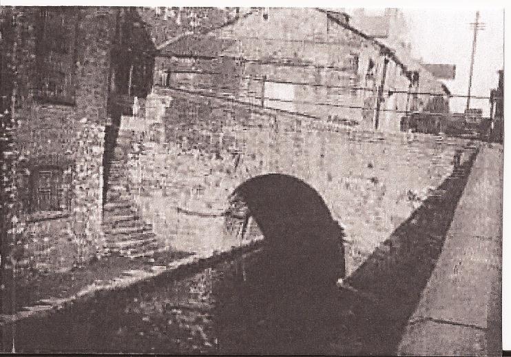
Crockherbtown became a refuge from the muddy, violent and shabby town for Aldermen and wealthier merchants and by the 18th century elegant Georgian town-houses were appearing among the thatched cottages. All had long front gardens, and it is thanks to this that today’s Queen Street has the generous breadth it does. The East Gate and West Gate were pulled down in 1781 as the moribund Corporation, under pressure from the growing new class of industrialists and traders, attempted to reduce chronic congestion along the single-track highway, and then the opening of the Glamorganshire Canal in 1794 fired the starting pistol for the Industrial Revolution to commence in Cardiff. The Canal used the ditch of the Town Wall to take it round the town, and this entailed a 105m (345ft) tunnel under Crockherbtown, the only place on the Canal’s entire 25 mile route where buildings blocked the way. At the northern entrance to the tunnel was Crockherbtown Lock, lock 50 of the Canal’s 52 locks, where the barges were marshalled before entering the amazingly atmospheric, pitch-black passage, known universally as ‘The Ole’ (it ran between today’s Friary and Queen’s Arcade). The Canal would be a Cardiff emblem until the late 1940s when the Council filled it in with the characteristic stupidity that has been an abiding feature of Cardiff’s rulers.
The opening of the first Bute Dock in 1839 saw another waterway pass under Crockherbtown: the Dock Feeder from Blackweir in a shorter tunnel further east (this has survived, albeit as an undercover drain between Park Lane and the bottom of Churchill Way). Then the opening of the Taff Vale Railway from Merthyr to Cardiff in 1841 gave the town a new eastern perimeter to reach for, as well as its first public railway station, called Crockherbtown (renamed Queen Street in 1887). With boomtown Cardiff’s population now going off the graph, the entire area south of Crockherbtown rapidly filled with terraced streets by 1860 and it became a priority to clear away the pre-industrial town. In 1863 the blockages at the western end were removed and by the time Crockherbtown was widened and renamed Queen Street in 1886, High Victorian bombast had superseded country town understatement from one end to the other, virtually all private residences had gone (although the last domestic dwelling in the Street hung on until 1925 – what is now Sainsbury’s stands on the site), and Cardiff’s premier shopping thoroughfare was in place. The name is now only applied to a service lane at the rear of Queen Street and, in its Crockerton form, to a dreadful Wetherspoon’s drinking factory on Greyfriars Road. That said, the ½ mile length of Queen Street that buried Crockherbtown is, for all it’s prominent faults, one of the great walks of Wales, a truly public realm with a Big City sense of enclosure and that gentle curve of the old country highway still pulling you onwards. A Welshman or Welshwoman standing on the same spot in Queen Street for 10 minutes is guaranteed to see someone they know from the chain of links that is Wales. Try it.
•CYNTWELL In 1093 coastal Morgannwg was captured by murderous Norman freebooters and over the next century organised as a feudal economy. In the lower Ely valley those who weren’t slaughtered or didn’t escape to the hill country became slaves, servicing the extravagant lifestyles of the self-appointed bishops of Llandaf who had crushed the Celtic church and into whose manor the area had been incorporated. Throughout the entire medieval period the Ely valley remained undeveloped, populated by a few hundred Welsh speakers who lived off the land and paid tithes to fill the bishops’ larders. The only opportunities for advancement lay along the ancient highway across the coastal plain, the prehistoric trail and Roman Road which now assumed extra importance as the pilgrimage route between the two revered cathedrals of Llandaf and, 120 miles west, St David’s. Along this muddy, rutted, narrow track scattered resting places for weary, hungry and thirsty pilgrims began to appear. Half way between the ford over the river Ely and the long slog westwards up Tumbledown, Saint’s Well developed in an early example of exploitative niche marketing. By the time Catholic hegemony was overthrown in the 16th century Protestant Reformation, the enterprise was long forgotten but the name endured as a hamlet of tumbledown cottages along Cowbridge Road West deep into the 19th century. A peculiar, partial-Cymrufication to Cyntwell took place over time, probably due to misunderstanding by Victorian map-makers sent from London. Cyntwell had long disappeared due to road-widening when the Caerau housing estate was built in the 1950s and a few streetnames at this spot revived the name. It not only makes no sense in Welsh, English or Wenglish, but also sounds obscene to English-attuned ears if the Welsh ‘y’ is pronounced correctly. There never was a saint and there never was a well – so let’s go with this silly bastardisation.
•GWAUN TREODA Let’s travel back in time 3000 years to an aboriginal burial ground of the Silures, a Celtic tribe of tenacious longevity whose descendants still constitute the majority in today’s south-east Wales. On a tongue of sandstone above the flood plain and watered by a tributary stream flowing down from the Wenallt to the Taff at Llandaf, these common lands became the hub of the rich proto-Welsh culture in the lower Taff valley. After the 300-year Roman occupation the name Gwaun Treoda (Meadow at Oda’s home – Oda’s identity has never been established) began to be applied to what had become an important gathering ground for the people of Cibwr in the cantref of Senghenydd, the administrative divisions in this part of the well-organised kingdom of Morgannwg. Anglo-Saxon attacks were fended off with the aid of Castell Cibwr, raised on the old burial ground, while Christianity established itself with an outlying chapel of Llandaf’s early church next to the castle. For a millennium Gwaun Treoda was integral to Welsh life until the long struggle against the Anglo-Normans between the 11th and 15th centuries eventually destroyed its significance (along with its church, castle and social sphere). The Normans replaced the Welsh structures with the controlling, oppressive, manorial and shire systems and the Latin church, and here Whitchurch developed. Gwaun Treoda was progressively nibbled away, the new turnpike road to Merthyr sliced through the shrinking area in 1767 and the name fell into disuse as Glamorgan anglicised in the 19th century. All that’s left today is the desultory, worn-out Whitchurch Common, barely 10% of Gwaun Treoda’s original area and lacking both communal pride and individual identification. But the name has clung on (in mutated form) in nearby Wauntreoda Road and Plas Treoda, and bilingual signing plus general re-Cymrufication give hope that perhaps the venerable story of Gwaun Treoda is not yet over.
•LOWER SPLOTT In 1891 Cardiff’s East Moors were obliterated by the vast, fire-breathing Dowlais Iron Works, relocated from the windswept mountains of Dowlais Top 30 miles north. Founded in 1759, Dowlais had became the world’s greatest ironworks under the management of John Guest (1722- 1785) and subsequently his grandson Josiah Guest (1785-1852). The Works had already been instrumental in the establishment of Cardiff as a major port, the Merthyr ironmasters Crawshay, Homfray and Guest having funded the construction of the Glamorganshire Canal in 1794 to facilitate the movement of their iron to the coast. Now the Dowlais Works would establish Cardiff as an industrial centre. The Glamorgan ores had run out so ores were having to be imported to Cardiff, taken by rail to Merthyr and then the finished product (principally rails) had to do the journey in reverse. To compete with other iron and steel makers the Guests agreed a lease with the Bute estate who owned the land and built their huge, integrated, state-of-the-art plant, at the time the world’s largest, in the perfect position to export from the just-completed Roath Dock (the original Works at Dowlais would limp on until final closure in 1930).
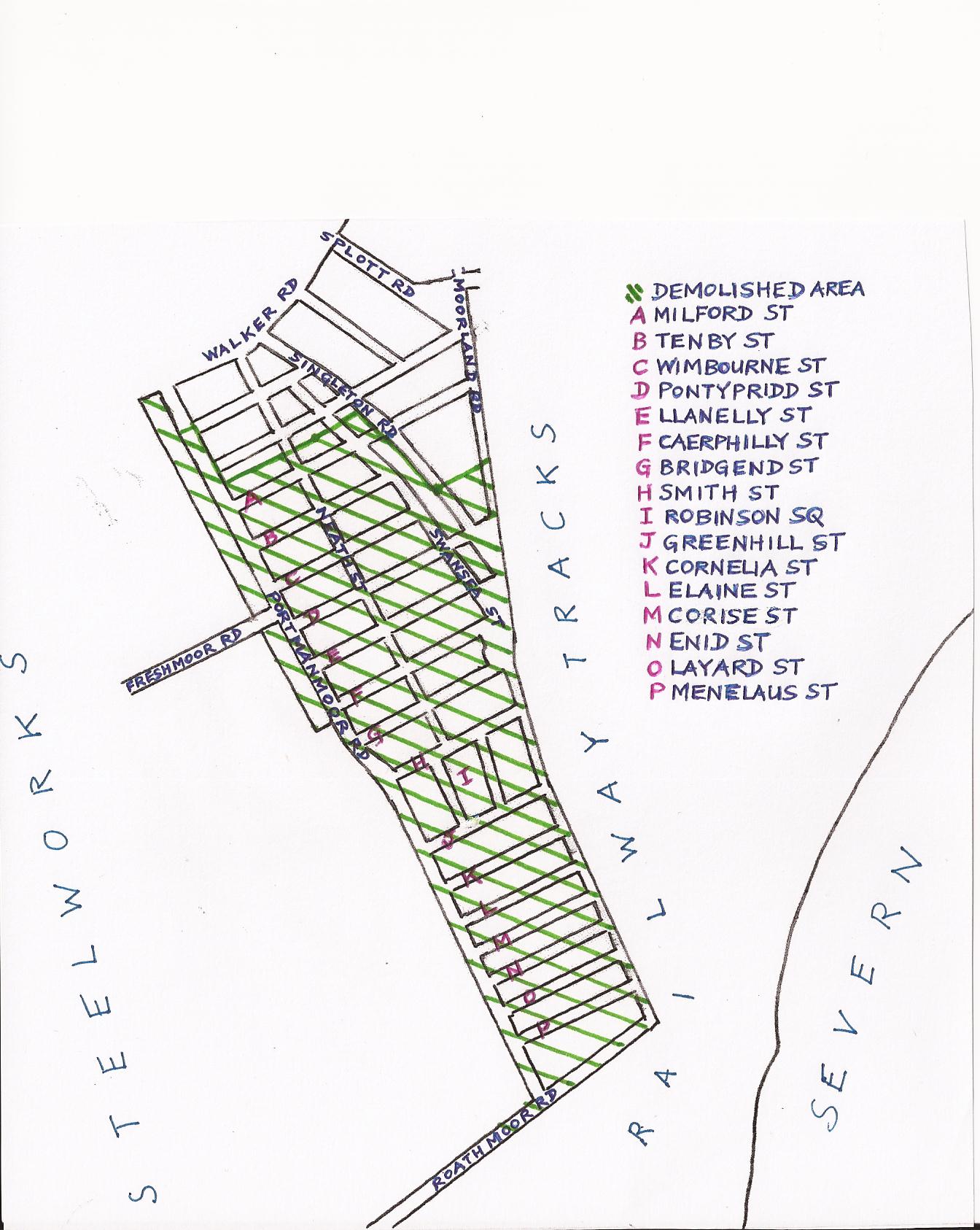
In 1895 a rectangular grid of terraced streets to house the workers and their families was constructed all down the east flank of the new steelworks, from Walker Road to the Severn foreshore. Known as the Dowlais Cottages, they were solidly built with stylish late-Victorian gothic touches, and rapidly filled with workers moving from the dying iron towns of north Glamorgan. The legendary warmth and solidarity of the Welsh valleys came south and from henceforth Splott became the part of Cardiff most fitting the Welsh proletarian archetype. The blast furnaces and chimneys would dominate the city’s skyline for the next 87 years, spewing out phenomenal levels of pollution. For generations, Cardiff air was thick with soot, ash, acrid vapour and chemical fumes. By day the city was often shrouded in darkness as smoke and steam blocked out the sun, while at night a spectacular pyrotechnic show of leaping flames and arcing sparks roared and crackled. Dowlais wives got used to checking which way the wind was blowing before putting out their washing, lest it be covered in a fine red dust. The ear-splitting metallic clashing and hissing of the works, the volcanic explosions of red-hot slag being dumped into the sea, the deafening blasts of the hooter signalling a change of shifts and the 24-hours-a-day thundering of the coal and iron wagons on the encircling railways synthesised into an industrial-age symphony. Lower Splott was a tough place to live alright, but Cardiff has had few communities of such collective heft, neighbourliness, friendship and sheer happiness. In this environment the most famous Cardiffian of all time learnt all she needed to know about money, men and life: Shirley Bassey grew up at 132 Portmanmoor Road under the Dowlais chimneys. In another example of the folly of Cardiff planners, virtually all of Lower Splott was demolished in the early 1970s and the people dispersed to far-flung new estates at Pentwyn and St Mellons. The pretext was concern for health; the true motive the usual one of wanting to maximise land values. And, in any case, the demolition was soon made pointless by the closure of the steelworks in 1978 – a devastating blow to Splott from which it has still not recovered.
Only Aberdovey Street and Aberystwyth Street were spared, leaving stranded link Swansea Street as a thoroughfare without a single postal address on it until a couple of infill flats recently went up. Looking at the rather desirable surviving homes today, exactly the sort of inner-city houses people want to live in, it is infuriating that a special corner of Cardiff is no longer with us. The Dowlais Cottages made way for Moorland Park – a paltry, vandalised, ring-fenced fly-tip – and serried ranks of sprawling, lifeless, garbage-strewn ‘business parks’ where most of the jerry-built sheds stand permanently empty. The only vestiges of Lower Splott left are suggestive scraps of sandstone rubble nobody bothered to clear along Tidal Sidings and, incongruously, Bridgend Street Football Club. Playing at Willows School, with their HQ at the New Fleurs, the only remaining original building on Portmanmoor Road, Bridgend Street have climbed the Welsh soccer pyramid all the way from local Sunday leagues up to level 4 (Welsh League Division 3) and now only have four Cardiff clubs (Cardiff Met, Caerau Ely, STM Sports and Ely Rangers) to overhaul to become the city’s top-ranking Welsh football club. That’s some achievement for a club from a place that doesn’t exist – except in Splotties’ hearts.
•NEWTOWN Of all the vanished places in this list, only Newtown gets to have a memorial. Designed by David Mackie and unveiled by Charlotte Church in 2005, it’s a low Celtic Knot thingummyjig in brick and stone with Welsh and Gaelic script, located next to a budget hotel in Tyndall Street (the brothel of choice for Magic Roundabout prostitutes). Why, of all Cardiff’s lost communities, has Newtown alone been picked out for special treatment? The answer is in the greater political leverage wielded by Cardiff’s Catholics compared to all other groups – and that includes the Welsh.
We hear much of the Irishness of Liverpool, New York, Boston, Sydney etc, but it is a little-known fact that Cardiff, pro-rata, received more Irish immigrants than anywhere else on Earth in the tragic Irish diaspora of the 19th century. When the 2nd Marquis of Bute (1793-1848), already the richest man in the world thanks to Welsh coal, decided in 1846 to ship over 10,000 starving Irish fleeing the Great Famine, as cheap, passive, indentured labour to build docks and railways, undercut Welsh wages and break strikes, Cardiff had a population of 15,000. Virtually overnight, 40% of the town was Irish. And, in a bitter irony, of all the ethnic groups to arrive in Cardiff it was these Celtic cousins who would prove most resistant to assimilation, and these fellow sufferers under the English yoke who delivered the knock-out blow to Welsh as the majority language of the town. They were not from the lettered, radical Irish culture of Joyce, Behan, Wilde and Beckett, nor were they from the Irish tradition of rebellion and republicanism; they were from the illiterate, inward-looking, booze-sodden, Pope-fearing strand of Irishness, a strand with zero empathy for the Welsh cause. This sudden influx of so many essentially medieval people into a modern town caused major ruptures and set Cardiff’s social and political development back decades. Nonconformist, Welsh-speaking, politically radical, trade unionised Cardiffians did not gel well with the lumpen proletariat Catholics who undercut wages and lacked the awareness to do anything other than quake before power. The conservatism, backwardness, subservience and pathetic gratitude of these skeletal paupers erased what little radicalism and independent spirit Cardiff had managed to accrue in the face of centuries of feudal repression and turned it into the most rightwing, philistine place in Wales – a position it would take generations to shake off and, in many ways, an underlying handicap running through the contemporary city’s affairs. The children, grandchildren and great grandchildren of the Cardiff Irish became many things – but few became Welsh. Even now there is more likelihood of a first generation Cardiff Englishman embracing Welshness than a sixth generation Cardiff Irishman. British? Yes please! Welsh? Never! The reason for this masochistic eagerness to grovel before the very state that killed, persecuted, impoverished and starved their ancestors is quite simple: the Holy Father says so. To the Vatican, Cardiff is an archdiocese in somewhere called Englandandwales, a place invented in the 12th century by Pope Innocent III (1160-1216) in order to eliminate the distinctive and independent Celtic Church and assert papal power throughout Europe. And, since Popes are infallible and hand-picked by God: end of debate. Pope Francis, the current incumbent (the 266th), seems perfectly content with this 800 year-old position. So, to an unreconstructed and unlapsed Catholic, Wales does not, and must not, exist. The time is long overdue for Welsh Catholics to ditch this insulting relic of conquest and campaign for independent status.
The 2nd Marquis of Bute, contrary to the sycophantic nonsense peddled about him in Cardiff ever since his son founded the Western Mail in 1869, was nothing more than the epitome of the new breed of monopoly capitalist for whom no amount of wealth and power was ever enough. He didn’t give a damn about Cardiff; he just wanted the cheapest labour he could find. With coal-ships returning empty to his dock and passing the Irish coast anyway, the ravenous hordes made for handy ballast too. Chucked off the ships before they entered the inner harbour, they had to crawl into Cardiff across the claggy inter-tidal muds, arriving in such a state that for years they were cruelly known as ‘mudflappers’. To house them, the Bute estate threw up Newtown in 1850 on either side of the Great Western Railway (GWR) and just north of the already existing 1839 dock. This was the first foray of the Butes into mass housebuilding and a very bad job was done indeed. The Irish were generally treated as sub-humans by the British establishment at the time, so no attempt at quality was made. The damp, insanitary, structurally-compromised 2-up-2-downs were crammed in around open drains with no concessions made to aesthetics. The homes routinely contained as many as 50 people each, living in conditions of gut-churning filthiness and regularly decimated by typhoid and dysentery. Surprisingly, these genuine slums outlasted the slightly later, much higher quality, Bute estate housing of Tiger Bay by nearly a decade, not being pulled down until 1966. A point that needs repeating here to counter the misinformation put about by Newtown nostalgists is that Newtown was on BOTH sides of the GWR, not just the south. In fact the earliest streets built were on the north side, in Adamsdown (Pellett, Duffryn, Garth and Morgan). Next came more tiny streets in an eastward extension off an improved and widened Whitmore Lane which was renamed Adam Street (Godfrey, Ivor, Victoria, Davis, Kite and Buzzard), and only after that was Newtown extended south of the mainline railway (with a connecting footbridge, Pont Haearn, demolished in 2015) when Pendoylan, Thomas (soon renamed Roland), North William, Ellen and Rosemary Streets were completed in 1855. Cardiff’s ‘Little Ireland’ was born.
With the Taff Vale Railway (TVR) of 1841 forming Newtown’s western limits, the addition of the Rhymney Railway in 1858, sweeping down to the docks on a high embankment to the east, and then the gigantic Bute East Dock along with its canals and feeders in 1859, meant that Newtown quickly became entirely encircled by railways and waterways and even more of a monochrome ghetto. From the above chronology, incidentally, it can be seen that the frequently-heard claim that “the Irish built Cardiff” is not true. The three key infrastructure projects that turned Cardiff into the world’s carbon capital (the Glamorganshire Canal, the Bute West Dock and the TVR) already existed before the Irish arrived. Surprise, surprise: the Welsh built Cardiff (the surprise being that it needs stating).
Newtown’s most famous son, champion featherweight boxer ‘peerless’ Jim Driscoll (1880-1925) from Ellen Street, where he lived all his life, is remembered today by a statue on Bute Terrace, dumbly positioned outside the preening tower of the Radison Blu hotel. Driscoll, whose premature death prompted the biggest funeral Cardiff has ever seen, fought as hard for his beleaguered community as he did in the ring, being instrumental in sanitation improvements and poor relief. He would have turned in his grave when the class warriors of Cardiff Council flattened Newtown in 1966 despite a long and passionate local campaign – the better to boost rateable income and clear the central city of undesirable proles (the Council achieved their aim and by the 1970s Cardiff city centre barely had a single resident; the next 30 years were then spent desperately trying to undo the policy and attract people back). The community was broken up and scattered out to new estates at Pentrebane and Trowbridge. To rub salt in the wounds, the light industrial ‘trading estates’ that were erected on the site have all in turn been demolished just 40 years later to become overflow car parks and empty lots where speculators are being induced to erect more unwanted office blocks (called, with thudding predictability, ‘Capital Quarter’ – two words worn to meaninglessness by overuse in Cardiff). After the scandalous removal of the Vulcan pub in Adam Street in 2012, nothing whatsoever remains of Newtown bar a tantalising fragment of wall in Ellen Street. Unless you count that Tyndall Street memorial.
•RHYDWAEDLYD In the late 11th century the Normans, having conquered England in four years flat and established a mighty militaristic state with imperialistic ambitions on battle-hardened Wales’ doorstep, turned their attention westwards. Gwent and Fflint were the first to fall and then in 1091 lowland Morgannwg was overrun by the terrorising troops of Robert Fitzhamon (c1050-1107) after a decisive battle near modern Rhiwbina (the precise location has never been established, key events in Welsh history having long been brushed under the carpet). The army of the last Welsh king of all Morgannwg, Iestyn ap Gwrgan (c1040-1093), was butchered somewhere near today’s Butchers Arms and such was the slaughter that the stream running past here down from the Wenallt was henceforth called Nant Waedlyd (Bloody Brook). Specialising in blinding, castrating, lynching, beheading and burning, Fitzhamon brought the derelict Roman fort in Cardiff back into use and set himself up as the first Lord of Glamorgan. An estimated 50,000 people were killed in his south-east Wales campaign – and it tells you all you need to know about Cardiff that the Welsh capital has not one single memorial to them yet happily commemorates the genocidal criminal Fitzhamon (as well as all his successor Lords of Misrule). Try to imagine a Hitler Boulevard in Paris and you’re getting warm.
The quick victory the Normans were used to achieving didn’t happen – partly because of the terrain, partly because the Welsh were past-masters of guerrilla tactics after long defensive wars against Romans, Vikings and Saxons, and partly because, unlike the motley and very recent Anglo-Danish aggregation of England, Wales had the patriotic fervour, evolved sense of identity and just cause around which to rally. By 1100 the Normans had been restricted to the low-lying fringes of Wales and for well nigh the next 350 years the Welsh fought, ultimately unsuccessfully, to evict the ever more powerful Anglo-Norman forces. The Welsh Wars of Independence, in which 25% of all Welsh people were killed, remain the longest armed conflict in history so far (I bet you didn’t know that).
Meanwhile, through the centuries, a significant hamlet grew where an ancient track down from the mountains forded the Nant Waedlyd. Called Rhydwaedlyd (Waedlyd Ford), it remained a pastoral Welsh-speaking backwater of thatched cottages, market gardens, tenant farmers, mills and piggeries on the undulating, wooded slopes three miles from Cardiff right into the 20th century. The opening of the Cardiff Railway (CR) in 1909 was the beginning of the end. The CR, a Bute estate venture intended to grab even more of the coal trade, would be the last new railway built in the UK until the Channel Tunnel line in 2003. It was that rarity, a Bute blunder, and was never profitable, closing as a goods line by 1931, but it had a big influence on the spread of suburbia either side of its east-west route from Heath to Coryton – a shallow cutting that went right past Rhydwaedlyd. Among the suburbs that the railway induced was Rhiwbina, conceived as part of the utopian ‘Garden City’ movement. A group of Cardiff intellectuals (NOT a contradiction in terms, I’ll have you know!) led by Herbert Stanley Jevons (1875-1955), professor of economics at the University College, and inspired by the establishment of Letchworth Garden City in England in 1903, formed the Cardiff Workers’ Co-operative in 1912. They bought the lands of Pentwyn farm north of the CR and completed the first batch of houses in Y Groes, Lôn Isa and Lôn-y-Dail in 1913. Rhiwbina was born and Rhydwaedlyd was binned, for reasons that are not entirely clear. The eloquent Welsh names that are everywhere in Rhiwbina were devised with relish by WJ Gruffydd (1881-1954), poet, Liberal politician and Professor of Celtic Studies at the University. It seems odd that he could find no place for the original Welsh name, and odder still that he should choose the name of a farm nearly two miles away (still operating) up the Wenallt. Had he chosen the nearest farm, Rhiwbina would have been named Pentwyn (as it turned out, Cardiff got a suburb named after another Pentwyn three miles east in the 1970s anyhow).
Rhiwbina’s important attempt to bring co-operative living and common ownership to Cardiff was eventually undone by forces beyond the Co-op’s control. World War and economic depression meant the Co-op never had the resources to implement more than 20% of the plan; private developers took up their option on the remaining lands and made no bones about aiming their homes at the very rich; the competitive values of the Anglo-American profit motive took their toll; the broad mix of tenants from all classes gradually withered; a narrow, predictable spectrum of owner-occupiers extended Rhiwbina northwards and eastwards over adjacent farmlands; and the 1968 decision to sell the leaseholds of the original Garden Village marked the formal end of the experiment. In Rhiwbina’s 1930s heyday Cardiff’s Tory papers used to sneeringly call it “Little Moscow”; today it’s more like Little Chef, judging by the waistlines of the ‘independent’ councillors the ward keeps electing. Bloody shame.
•SALTMEAD If you require clinching corroboration of the old Marxist maxim “all property is theft”, look no further than the peninsular between the mouths of the Taff and Ely rivers, Cardiff’s waterlogged West Moors of creeks and bogs, once a muddy estuarine habitat regularly inundated by the tides where nature had dominion. The native Celts established no settlements here, sensibly preferring to live on dry ground, but that respectful relationship between humans and this environment ended with the Norman assault on Wales in the late 11th century. The era of the robber barons began – an era that has not ceased to this day.
No less than nine times the West Moors have changed “ownership” in dodgy deals since that Norman seizure (via the bishop of Llandaf, the Cistercian monks of Margam Abbey, the de Clare dynasty, the Despenser dynasty, the Cistercians again, the English crown following the dissolution of the monasteries, the Lewis dynasty, the Windsor dynasty and finally the Windsor-Clive dynasty – the Earls of Plymouth). Scarcely credibly, most of the Plymouth’s vast holdings in Glamorgan are still in their hands. Today, in the digital age, the 1000-year-old injustice remains unrectified.
The creation of Grangetown was an accidental consequence of the Plymouth estate’s exploitation of their valleys collieries. They built the Penarth Railway (PR) and Penarth Road to get the coal out to their 1865 Penarth Dock, major infrastructure projects marching across the pristine Moors on curving embankments and forming the Grangetown framework around which workers’ housing was squeezed. To the north of Penarth Road the area bounded by an 1875 loop from the Great Western Railway to the PR was filled with terraced streets between 1880 and 1900 and for a while went by the name Saltmead. The massive influx of workers into the booming coal port meant there was no shortage of tenants for the small houses, despite the permanent damp and the extortionate rents that added further profits to the Plymouth estate’s groaning coffers. In this corner of Cardiff there was the now familiar injection of Irish but most came from England, particularly the depressed agricultural counties of the south-west – hence the Anglo-friendly Saltmead name and the streets named after English shires. In such backstreets the unique cocktail of Welsh lilt, Irish brogue and Devon burr coalesced into the inimitable Cardiff accent. Saltmead’s reputation never recovered from the problems of its damp-riddled housing stock, crumbling back into the briny marshes barely 10 years after completion owing to Plymouth estate pennypinching. It took decades to damp-proof and rehabilitate, by which time the Saltmead name had been quietly dropped – being a little too accurate a description of the area. Even main thoroughfare Saltmead Road was not allowed to retain the name, becoming Stafford Road. The embarrassing “Upper Grangetown” didn’t last long either, and now the much-altered but largely extant grid of streets is just an intriguing quarter of ‘the Grange’, Cardiff’s durable multi-cultural guts, fashioned from saltmarsh and sardonic back-chat.
•TEMPERANCE TOWN Here is a Cardiff zone that repeated meddling has never managed to get right. In 1850 the Taff was straightened into a new cut as part of the immense works to gain ground for the South Wales Railway (later GWR) from Chepstow to Swansea. Right in front of the new station, on hastily-filled swamps that had been the bed of the river, Temperance Town was laid out in the 1860s in a tight block of eight streets: Saunders Road (in front of the station), Wood Street and Park Street running east-west; Havelock Street, Scott Street, Raven Street, Gough Street and Eisteddfod Street running north-south. The landowner, Edward Wood (1829-1897), was grandson of one of Cardiff’s all-time monsters, the utterly unscrupulous lawyer and banker John Wood (1755-1817) who made his fortune as Bute-appointed Town Clerk at the time of the enclosure of the Heath in 1801, setting his ancestors up for generations. Edward Wood was a self-righteous teetotal campaigner against demon drink, so Cardiff’s first purpose-built working class area didn’t have a single pub but did have a Temperance Hall on axis road Wood Street – hence its name. This crude attempt at social engineering failed (as have all efforts in Cardiff to fit people to the development rather than vice-versa). Temperance Town was soon the very definition of intemperance, with more illegal drinking dens, brothels and crime than anywhere else in Cardiff. And, because the cottages had been cheaply built with no thought to sanitation or structural integrity, within no time it was an unhealthy, dog-eared slum. The first thing visitors to Cardiff saw as they left the station could not have been calculated to give a worse impression, and the Council had Temperance Town earmarked for demolition as early as the 1890s.
They got around to it in 1937, galvanised by the GWR’s posh art deco Portland stone rebuild of the original station in 1934. Without consultation and ignoring the close-knit community’s opposition, the people of Temperance Town were dispersed to new estates at Leckwith, Ely and Tremorfa and their homes bulldozed. The site remained a large wasteland used as a car park until the Central Bus Station opened in 1954. The Council congratulated itself on its farsighted integrated transport hub and the exciting modernity of the surrounding office blocks that rose in the 1960s as the few remaining traces of Temperance Town along Wood Street were erased: the gothic 1879 Board School, the 1883 St Dyfrig’s Church and finally, in 1969, the neo-Georgian Temperance Hall itself (it had become Wood Street Congregational Chapel in 1869 and was Cardiff’s biggest Nonconformist place of worship).
The fate of each of the replacement developments encapsulates all the failings of Cardiff’s inept leadership. Terminal House had an expensive face-lift in 1984, but so irredeemably slimy and seedy had it become it was given up as a hopeless case and knocked down in 2009. The Empire Pool was demolished in 1998, just 40 years old, to make way for the grim grey box of the Millennium Plaza “entertainment complex”, already looking ripe for the attentions of Cardiff’s overworked demolition gangs. St David’s House would be largely empty were it not for charity shops and the offices of Cardiff Bus. Marland House rapidly became an oppressive hell-hole where Cardiffians went to claim Housing Benefit and get on the ever-lengthening housing waiting list, with scuzzy, low-prestige outfits like Spar, Londis and Burger King along the ground floor. Central Square in front of the station could not have been more inappropriately named – Peripheral Oblong is more like it – and its most impressive feature, William Pye’s hulking 1999 sculpture Cadair Idris, proved such a temptation for graffiti sprayers, weak bladders and vandals that it had to moved out of harm’s way to Hamadryad Park in Butetown. The interesting railway water tower stands peeled and stained, its 1986 bright yellow daffodil mural faded to a dirty smudge. Hideous Southgate House is mostly empty apart from an army recruitment office positioned brazenly to ensnare deprived and dim kids as they get off the trains. And, with exquisite irony, the planners’ own planning office was so badly planned it lasted just 30 years and now they’ve pulled that down too! Now Council leader Phil Bale can be heard uttering the same hackneyed jargon as all his predecessors as it’s all swept away for the latest ‘masterplan’, with a completely unnecessary BBC Wales vanity project as the centrepiece. How embarrassing for the capital of Wales that visitors will soon be greeted by the very symbol of British contempt for Wales, a London-based organisation that abuses its virtual monopoly here by cutting Welsh programming by 40% in the last ten years and spending only £70 million of the £190 million annually raised from Wales by the license fee. One thing’s for sure: the promised ‘dramatic overhaul’ will look nothing like the architect’s sketches. The fact is that 70 years of running round in ever-decreasing circles since old Temperance Town bit the dust have achieved the seemingly impossible: a marked deterioration. That mythic first-time visitor to Cardiff, emerging blinking from the station, has long been faced with pigeons, litter, chewing-gum, taxi ranks, bus shelters, building sites, empty offices, fast food outlets, Big Issue sellers, rent boys, winos, the British Army, Oxfam, Lifestyle Express and a general air of small town dilapidation as their introduction to the city. Prediction: the preening phalanxes of anonymous corporate concrete and glass currently rising will be even less impressive.
•TIGER BAY For the full, calamitous tale of the rise and fall of Tiger Bay, see http://tinyurl.com/hbq3yxt, and, to add insult to injury, the latest speculative development area alongside Roath Basin (one of Cardiff’s three surviving docks), based around new BBC studios and the heard-it-all-before aspiration to become “a European destination for the media and creative industries sector”, has been named Porth Teigr. This impertinent piece of hollow post-modern lip-service neatly sums up the Bay project’s bankrupt ideology: after being demonised and excoriated when it really existed, now it’s decided that Tiger Bay’s been safely dead long enough to be glibly name-checked in a crass lurch for rootsy credibility
•TREDEGARVILLE The Morgans of Tredegar were unusual among the large landowners of Wales in that they were actually Welsh, tracing their lineage back to Rhys ap Gruffydd (1132-1197), a king of Deheubarth famed for his triumphant 40-year resistance struggle against the Norman invaders of what is now Dyfed. The Morgan clan built up their holdings through all the vicissitudes across the centuries until they possessed vast swathes of Gwent and Glamorgan and, at the start of the industrial revolution, were the only serious rivals to Bute power in Cardiff. By then they had ditched their Welsh character and assimilated into the British landed gentry, scaling the peerage ladder via knight, baronet and baron to ultimately reach viscount. It was Charles Morgan (1792-1875), the 1st Baron Tredegar, who gave the go ahead for the Tredegarville development from his mansion at Tredegar Park near Newport in 1857. Covering orchards and pastures on either side of Roath Road (today’s Newport Road) between the just-completed Rhymney Railway and the ancient Plwcca Lane (today’s City Road), Tredegarville was Cardiff’s first expansion east of Crockherbtown and Cardiff’s first middle class suburb. Large opulent villas, aimed at the growing mercantile and professional classes, were laid out on a grid of streets to the designs of the Tredegar Estate architect William Habershon (1818-1892) and for a good half century this was one of Cardiff’s most successful and coherent neighbourhoods.
However, by the 20th century Tredegarville had been engulfed on all sides and the flight of the rich from the inner city saw the graceful Victorian housing gradually metamorph into offices, schools and surgeries. Luftwaffe bombs in 1941, road-widening after the war, a doomed attempt to turn Newport Road into Cardiff’s ‘financial district’ in the 1960s and speculative office developments on Fitzalan Road and Fitzalan Place (Tredegarville’s Grove Road and South Grove) in the 1970s meant nothing remained of Tredegarville south of Newport Road by 1980, apart from the primary school on Glossop Road, which also preserved the Tredegarville name. The demolition of all the superbly-detailed gothic villas was to no avail: most of the offices are either vacant or have been converted into student halls and half-empty apartment blocks, the dubious honour of being Cardiff’s business quarter shunted elsewhere (currently Callaghan Square). On the north side of Newport Road the entire magnificent stretch of Victoriana between Queen Street and City Road has gone barring Number 19, the 1858 Oddfellows House, originally the Spanish Consulate. Again, this was a category error by council planners: the ugly offices chucked up between the 60s and the 90s in their tawdry strivings for a mini-Manhattan at the behest of speculators are nearly all to let, meaning Newport Road was wrecked for nothing.
What remains of Tredegarville can be seen on surviving streets The Walk, The Parade, West Grove and East Grove where the stuccoed villas, tree-lined avenues and spacious dimensions still appeal, notwithstanding time’s ravages and the glut of cosmestic dentistry practices, dodgy private schools and chartered accountants. Worth seeking out particularly is Cardiff & Vale College (formerly Coleg Glan Hafren) on The Parade, a creamy French Renaissance carnival built in 1895 (as Cardiff High School for Girls, which amalgamated with the High School for Boys and moved to Cyncoed in 1973). Also noteworthy is the Mansion House at the top of West Grove, a cumbersome stately pile built in 1891 for department store tycoon James Howell (1835-1909), and official residence of the Lord Mayor and venue for formal civic occasions since sold to the city in 1913. Howell’s previous house on The Walk is interesting; now flats and between 1920 and 1953 the Prince of Wales Hospital for limbless WW1 veterans, it’s a magisterial gothic hunk in Cardiff’s signature Pennant sandstone with an ornate cast iron entrance canopy plus a freakish replica in Radyr stone of the Neolithic cromlech at St Lythans in the front garden! Along with the primary school, Tredegarville Baptist chapel on East Grove, built in 1863 with ballast stone from around the world carried to Cardiff on the Cory coal-shipping fleet, is the last bearer of the Tredegarville name.

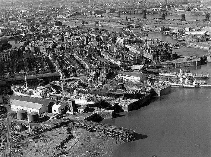
Pictures: Cardiff Central Library
Diagram: Dic Mortimer
Absolutely fascinating. Is there any way to reserve an advance copy of your Naked Guide book?
What an amazing piece. Thank you – having lived in Cardiff for 11 years now, I only realised Newtown was part of “Atlantic Wharf” where I now live. I didn’t realise it’s past!
Ah…Atlantic Wharf, I know it well…
You probably know that it was once the Bute East Dock. The 1859 Junction Canal built to connect the northern ends of the East Dock and the filled-in Bute West Dock still exists virtually intact (off Brigantine Place). Look out for an upcoming blog on Cardiff’s canals.
Didn’t the Junction canal go further over to join the Glamorgan canal?
dicmortimer, has anybody ever told you that you have a bloody awful sense of timing? Where the hell were you in 1961 when I was gloriously and effortlessly failing my GCE “A” Level in History,reading text books that bored the socks off me? Having read your piece on Cardiff, I feel certain that it would probably have taken a greater effort to fail had you been responsible for presenting the diuretic diet of facts with which I was force fed.
Thoroughly enjoyed it. Thank you.
Dear Frank.
Are you the guy who wasted 2/3 years of your youth working for the Northern Ass. in Windsor Place in the early 60’s. If so give me an email.
Richard Gillmore
My grandfather arrived over here on a boat 1910 from Dungarvan Ireland. My grandmother arrived from Cork a few years earlier. They both met here in Cardiff and married and went on to live in the Dowlais Cottages. One point I feel I have to make is … I am welsh !! This theory of yours that granchildren do not take on the nationality of Wales is so very mistaken. Yes Im proud of my Irish roots and yes Ive spent many happy years and months in Ireland, but, I was born in Cardiff, South Wales. I am a Cardiffian and I am Welsh and so very proud to be Welsh. You hesitate to mention the words often found in the windows of pubs etc.
No Blacks
No Irish
No dogs.
Of course there are many Cardiffians with Irish roots who identify as Welsh; but there are even more who do not, despite the many generations that have passed since their ancestors arrived here. As I hope I made clear this is due not to Irishness per se, but to the dictates of the Roman Catholic church, which still refuses to recognise Wales as an entity to this day. The Vatican’s continuing grip on Irish hearts and minds is the reason so many ‘Irish’ Cardiffians I have encountered over the years are openly antagonistic to the very concept of Wales and surprisingly attached to Britishness. It does no good to gloss over this tension and sanitise the tricky Irish/Welsh relationship. This ancient and evolving relationship has never been properly examined – mainly because everything in these islands is filtered through an Anglocentric perspective. We are surely mature enough now in Wales to begin to face the complex reality (Cardiff’s very first “race riot”, for instance, was a Welsh v Irish conflict in 1848). The Republic of Ireland is the only independent Celtic nation on the planet, its Celtic cousin Wales is its nearest neighbour and the two countries are inextricably entwined, yet there is a peculiar lack of empathy and solidarity in the relationship. This needs dealing with, not sweeping under the carpet.
What a load of tosh, Dic!
Left to perish by an uncaring British government, would you be saying this if the Welsh experienced what the Irish did, if they were forced to flee to England, for sure they would embrace the English, piffle!
I was born in Newtown, these foisterings of your imagination are bizarre in the least, its nothing about being Welsh or Irish or anything else, my forebears suffered at the hands of the English back in those terrible times but the suffering never ceased, no some like my paternal family had to change their family name to an English one to diminish the discrimination that went on until the latter part of the 19th century. What would you do Dic, shout it from the top of Pen Y Fan, I love my adopted country, I am a patriotic Welshman, we had to adopt our own identity because of attitudes like yours. not Welsh or Irish but as Cardiff people, its typical of your nationalistic ramblings to sell some copy. People are people, some like to call themselves this and that but at the end of the day none of us were left with any choosing, but we got on with it like many a disadvantaged disenfranchised group, I’m proud to be Welsh, I’m prouder of my Irish heritage but mostly I’m proud to be a Newtown Cardiffian!
Hi…is this THE Margaret Barry from Splott?
would love to hear more!! drop me a reply. xx
An interesting read. I had imagined that Newtown was cut by The South Wales Railway only to learn that the streets to the south were built what must have been not ten years after the line opened. I’m interested in the history of Cardiff and shall be returning to this informative and well written blog.
I was told just yesterday that people living in the St Fagans area used the name WALLER for what we now call Ely. I have never heard this name before but was assured by two elderly gents that in their youth it was in common usage.
On a 1840 map of Cardiff there is a place called Saint Wall which seems to be where Cyntwell is located. On the web a Saint Wall is defined as a place of sanctuary from the law therefore I wondered if the now derelict Cyntwell Church was originally Saint Wall Church hence the word WALLER.
Have you any knowledge on this term for Ely.
No, I’ve never heard that before. I’ll look into it. Those two elderly gents must be positively ancient as the Ely Estate was built 90 years ago in the 1920s (north of Cowbridge Road quite a way from Cyntwell). Perhaps it’s a local dialect-Wenglish bastardisation of (the river) Ely/Elai itself?
Re “Waller” as a name for Ely…I have been told but cannot confirm that Waller was the name of the main contractor which built the “bones” of Ely right at it’s inception. Can any one add or confirm???
They are both in their eighties. One of them was brought up in St Fagans and St Georges and the other was from St Brides. They said that when they were going to Ely the expression they and their contempories used was, `I’m going to the WALLER’. My spelling might be wrong but the pronunciation rhymes with `Fat’s Waller’.
I really like what your doing on this site. Thanks
P.S. One of the elderly gents tells me that the church I called Cyntwell and described as derelict is actually called St Mary’s. That’s the church on the hill with the iron age hill fort that overlooks Cardiff.
The thought occurs to me Alun that Waller could just be a variant of Welsh, Welshman, Wales etc (a few contemporary English words still contain this element, eg: Cornwall, Walnut, Walloon). The Vale, being fertile and low-lying, was a part of Wales deliberately implanted with Anglo-Norman settlers after the Welsh were driven out to the hills in the 12th century. The very placenames of the Vale reveal all: St George’s for starters! Those Welsh who remained were slaves and serfs only allowed to live in precise locations – such as the pre-existing hamlet of Ely at the river’s lowest crossing point. As happened in other areas where the conquest was early and the subsequent rapid colonisation kept the Welsh and the settlers separate (eg: Pembrokeshire, where an actual line of fortresses and watch-towers divided ‘the Englishry’ from ‘the Welshry’), perhaps this is an 800 year-old linguistic vestige of the way Wales was carved up. If so, it’s not just historically interesting; your old men in their 80s show that the past is present.
If you haven’t read it already, there’s more about Caerau hillfort and St Mary’s in a previous blog ‘The Castles of Cardiff’.
A very interesting read indeed, I’m glad I have met someone else with such an immense interest in Cardiff’s deep history as myself, and a fire for preserving those once important areas that now only dwindle in the names of streets and distant memories. I’m lucky to be able to say that my family dates back to Cardiff for a long time, even as far back as some records go, to the 1700’s and early 1800’s, and presumably further back.
I wonder if you can answer a question for me, it has been puzzling me for quite some time. Some of my ancestors as a family lived and were born in what was (an area of Cardiff labelled on the documents) called ‘the tunnel’ in the Crockherbtown area, and also Hills terrace. For some time I have wondered if this was just a street called ‘the tunnel’ or weather it was referring to the actual tunnel that was the Glamorganshire canal, although surely it cannot be the latter, as that would mean people actually lived inside the tunnel? Or was the street called the tunnel present over the canal tunnel? and why was this street specifically named ‘the tunnel’?
Many thanks with any help you are able to give me! And once again, its great to see someone else with such an interest in the history of the area past the industrial era for once!
‘Tunnel Court’ was a short, narrow street that sat directly on top of the Glamorganshire Canal’s tunnel. It ran south from Queen St/Crockherbtown to Cross Street with tightly-packed buildings on both sides. Built in the 1820s, it was still fully extant over 100 years later. Partial demolition occurred at the southern end when the Canal was filled in here in 1948 and then the remainder disappeared with the Allders development of 1960 (including the Tivoli pub which was on the Tunnel Court/Queen Street corner). Queens Arcade now covers its position.
The lady who mentions “The Waller” as a name for Ely might like to know that the construction company who built much of the area was Wallers…simple as that
Having been to school in Cardiff during the 50s, I found this article fascinating. Well done
I am researching family history, from Cardiff area. I found your writing very interesting. Thank you.
Why don’t you provide your sources? A blog like this needs proper referencing.
Great stuff! I’ve book-marked your blog already. As for the Welsh/Irish relationship, I’m afraid you’re right. All the older Cardiffians I ever knew who had no Irish roots always viewed the Irish as uncultured, insular and brain-washed into a terror of questioning what they were told to think or do. Welsh history wasn’t ever considered in Cardiff Catholic schools (at least not the three that I attended) which leaves you with the choice of trying to teach yourself. By the time my parents realised we knew more about Irish saints than the national anthem, it was too late. There’s still a lack of good reading on the subject of Welsh history, but not of interest. So much of our history has already been lost to us through a simple determination to ignore it. Let’s get it into the school system where it can flourish and hopefully no longer be ignored.
A first class read which brings back Cardiff as it truly was and is. Thank you.
Great stuff, love it!
I am a Welsh Mutt//mix of Welsh/Roman/Norman-English/West Country/Irish/Scots and who knows what else..
Mixed religions also, but above all Welsh to the core.
Growing up as a grammar schoolboy I was always made to feel that I was not truly Welsh but your
blog has helped me to understand the forces that have shaped the Vale and the Valleys and my
family evolution in Wales..
Family roots are deep within Welsh History including Chartist/Newport involvement.
Your blog on Cardiff located Eisteddfod Street and the deaths from typhus/cholera in the 1880,s
of my Great Grand Parents. (Temperance Town) This area must have been over the top toxic as my Grand Mother would never discuss it.
Thank you for an exceptional read
Bill.M.
Though I now live in Kent, and have done for over 40 years, I was born and grew up in Cardiff and in fact lived for 4 years at the old Duke of Edinburgh pub on Ellen Street as my late father worked for Brains Brewery. The pub had ceased to trade when we moved in but I have clear memories of Newtown and its residents and love any information and photographs related to it. I recently visited the city and found it incredibly hard to trace any sign of it, though we managed to find what was purported to be Ellen Street – the only recognisable remnant being the railway line and wall! If anyone has more information about the people, and any photographs especially of the pub (I only ever seem to find one or two of Jim Driscoll and family outside it) I would love to know. I am putting my email address in hope!. Very interesting read and trip down memory lane. Cardiff was, and will always be, in my heart and where my heart lies.
How can I put this without being indelicate and certainly not to be ‘sycophantic’; ‘Irish immigrants,’ you say in a particularly racist section of your piece. Check out the Oxford Dictionary; Immigrant – a person who comes to live permanently in a foreign country. Following the Act of Union and until its independence in the twentieth century Ireland was as much part of the UK as Wales. I think you should send this article to Nigel Farage, he is particularly interested in recruiting in Wales. I look forward to hearing your considered response.
Pingback: Cardiff A-Z: Q is for Queen Street | We Are Cardiff
Fascinating piece. Your writing really brings to life long disappeared parts of Cardiff. It’s a huge shame and an indictment of successions of planning department bureaucrats and local politicians that much of Cardiff’s architectural heritage has been so casually tossed aside. Perhaps it should be no surprise as so much of the city’s rapid growth was based on exploitative Carboniferous capitalism and short termism. A theme that persists to this day.
Nearly reached the end of Cardiff The Biography. Cardiff could do with some foresight in urban planning matters. It’s never too late; though the lack of thought displayed up till now hasn’t helped.
.Very.good.jim.driscolls.relatives.local.keep.up.good.work.good.on.you.dic.proud.irish.
Pingback: The history of Tyndall Street – and the lost community of Newtown, Cardiff | We Are Cardiff
I was born in Cardiff, and have Welsh ancestors, I can only assume this was due to the Irish famine. I consider myself as Welsh, with some Irish blood in my veins. I am proud of this, and have tried to trace my ancestry tree. This is not easy to do, as a lot of documents, birth, marriage, death, certificates etc, were destroyed by fire. So basically anything before 1875, doesn’t exist. This research gave me a passion for history, a subject I detested in school. I started to wonder why we were never taught about Welsh history, and wondered how come we had so many Castles, and evidence of historical events. Yet none worth learning about. I have found a few sites that tell of Welsh history, and some of these stories are astounding. In 1846 English teachers were sent to Welsh schools, and the children were banned from speaking Welsh, it was called (The Welsh not) they would be smacked if they did. Also anything published in Welsh was banned for years. Anything connected to Welsh history, manuscripts, artefacts, relics, etc, all destroyed. How could this be allowed to happen? And why? So the Welsh have no relevance in history. Nothing worth talking about. I think not ! I think the powers that be have also suppressed the Irish language, another attempt to wipe out stories of historical importance. Stories that prove a massive Royal cover up…. History should be based on the truth, if a language is ousted, and all evidence is destroyed, then history has no meaning at all..
“if a language is ousted, and all evidence is destroyed”
History is rewritten down the years. The enemy of the revisionist is old fashioned ink on paper. No amount of Wikipedia edits will burn every copy.
It is fascinating to read contemporary accounts of Wales down the years for their differing perspectives.
What a truly excellent read – thank you. My great-grandfather, Michael Sullivan, born in Cork in 1847, moved from Merthyr to Blaenavon, and then to Cardiff in 1892. He was an iron furnace man in Blaenavon, and it has never occurred to me before that his move to Cardiff came very soon after the Dowlais works opened in 1891. He lived at 303 Portmanmoor Road. His son John, my grandfather, married Mary Reynolds, originally from Caerphilly Street, and moved in with her family at 178 Portmanmoor Road in 1900, later moving to Layard Street, where my mother was born in 1906. All these addresses are contained within the Dowlais Cottages area.
Good to see comments still being posted six years after the original blog.
Yes, Butetown/the Docks, not the Bay. For me, the Packet will always be down the docks – and keep a space for Barry, the largest town in Wales and thought to be a part of Cardiff by many as it is.
Amazing history of a rapidly disappearing city!
Pingback: Ffair Ton – Tongwynlais.com
Great read, some great points too about the past injustices – and the Plymouth Estate are still flexing their anglo imperialist muscles, Labour-backed imperialists have ripped up leases to build 7000 houses, concreting prime green fields, which of course are owned by the Plymouth. Great knowledge of the Wenallt, the geography of the area, Pentwyn farm and Newtown.
Very interesting indeed. Originating in the Merthyr (Penydarren/ Dowlais) area, we endlessly decry our lost heritage, as once a center of the industrial revolution- almost all destroyed by short sited architectural hooligans of the council. You mention the Dowlais cottages are gone, (along with much of Splot), Is the Dowlais Hotel still there, do you know. Once one of Cardiff’s finest on West Bute Street.
Pingback: Cardiff catch-up | Dicmortimer's Blog
Absolutely fascinating, thank you so much for this – I don’t agree with some of the political commentary but the historical focus is truly engaging.
As a child born in The City Lodge, your narrative opens up such an informative view – so very different to the Establishment one. Much of what you say rings true. Many thanks.