Three rivers snake across a plain towards the sea, dissolving into a marshy labyrinth of treacherous, shifting channels. Twice a day huge tides roll in, blending fresh water and salt water into a swamp of sucking mud and swirling currents teeming with fish and waterfowl. When the tides ebb the rivers carve tortuous routes over the spongy moors before entering the great sea-river in a maelstrom of sandbars, foam-crested waves and ripping undertows, the haunt of salmon and dolphin, bittern and sea eagle. As the land rises gradually from the coast, reed-beds give way to thick forests of pine and birch, home to roaming herds of oxen and deer. Beyond, the wide delta is backed by an amphitheatre of hills clothed in a dense canopy of oak. It is from these hills that the three mighty rivers come, swollen by a thousand mountain tributaries. Each has its own personality. The western river is heavy and slow, the eastern river is forceful and probing, the central river is greedy and expansive. Thus, in Old Welsh, they will be named: the Elái, the Rhymni and the Tâf.
~~~
The Taff defines Cardiff, determining its location, topography, history, economy and indeed its very name: Tâf became Taff became Diff. There is another river Tâf in Wales, emptying into Carmarthen Bay at Dylan Thomas’s “heron-priested shore”, and the rivers Teifi, Dyfrdwy (Dee) and Tywy have the same etymology. In fact the longest rivers in both Scotland and England – the Tay and the Thames – also owe their names to this ancient Celtic root. Essentially then, “Taff” is a modern Anglo-Welsh version of a generic word for those special rivers that display classic fluvial qualities; this is the river’s river.
But the river that slopes through the city today is but a wretched apology for the wild, wonderful, capricious, flash-flooding, boisterous natural waterway it once was. Weirs, embankments, diversions, culverts, straightening, channelling, extraction, draining and, since the Barrage, entrapment and desalination have turned the Taff into a sorry specimen hardly worthy of its venerable name. Yet the 7th longest Welsh river remains Cardiff’s spinal cord, its condition the yardstick by which the city’s health and well-being can be measured.
Once upon a time the pristine river teemed with salmon and trout and coracle fishing was a common practice right up to the late 19th century. But the coming of the coal industry destroyed the thriving biosphere. Running black with slurry from the hundreds of mines further up the valley, it became uninhabitable for virtually all fish and water mammals. Following the collapse of the coal economy the river became clear again, but far from clean. A microscope and a laboratory are required to see today’s invisible pollutants. In the Taff’s vast catchment area a host of disused quarries and land-fill sites, often unrecorded and unmonitored, leach ammoniacal-nitrogen, toxic compounds and heavy metals into the waters; abandoned mines seep soluble arsenic and cyanide; bacterial pathogens produced by grazing livestock run off from the hills; and radionuclide waste from the 2nd largest nuclear polluter in the UK after Sellafield (GE, formerly Amersham, at Coryton) was flushed straight into the river for decades, only ceasing in 2010 when European law made such pollution illegal. The consequences for Cardiff, where all these poisons accumulate, have been deadly. Statistically significant excess levels of Crohn’s disease, leukaemia, congenital deformities and infant mortality are the price Cardiffians pay for the Taff’s torment – although the Council, the Health Authority and the Environment Agency would much prefer it if none of this was ever mentioned.
They would also like you not to know about Cardiff’s sewage system. One of the city’s distinguishing features is the smell of drains wafting up from beneath the pavements. Down the Bay it can be particularly bad: punters in Mermaid Quay gag on their black olive ciabattas when the vile stench suddenly assails their nostrils. They flee to the car park only to find that the stink lingers on clothes and skin for hours. The Harbour Authority throws up its hands in horror and instigates an investigation. Nothing more is forthcoming until the next time they get a complaint and the cycle is repeated. I know they’re preoccupied trying to flog real estate, so let me solve the mystery for them. The cause is a mix of cryptosporidiosis hominis, e coli, bdellovibrio predators and faecal streptococci. In short, shit. The sewage of half a million people is discharged as effluent into the myriad rivers that, via the Taff, culminate in Cardiff. Cardiff’s low-lying basin draws all this liquid into it. Normally it ends up at the treatment works on the Tremorfa foreshore, there to be discharged into the Severn. But heavy rainfall or blockages can easily cause overflows and backwashes before it gets to Tremorfa and Cardiff already had a high water table even before the Barrage. The city is effectively sitting on a pan of excrement which from time to time spills over the rim. Old Father Taff needs incontinence pads.
Rather than embrace and celebrate the river, Cardiff’s rulers have treated it as a problem to be mastered – not because of its frequent bank-bursting flooding but simply because it took up too much potentially lucrative land. Major works overseen by Isambard Kingdom Brunel (1806-1859) in 1849 eliminated the river’s sinuous route through the town centre by diverting it into a man-made channel, allowing development to spread along the river corridor. This did permanent damage to the Taff’s morphology by constraining it and altering its natural platform and channel geometry. Final castration was completed with the Barrage in 2001, removing the sole purpose of all rivers: the search for the sea. The result is that today’s Taff is not really a river at all anymore, just a feeder canal for a water feature. Until the day the Barrage gates are left permanently open the only true river running through Cardiff’s heart is a river of tears.
As the map from 100 years ago appended below shows, the Ely has been given the same treatment as the Taff. The leisurely meandering two mile stretch between Ely Bridge and Penarth Road was placed in a dead straight concrete gully in 1972, all to release 170 acres of land for car showrooms and unoccupied sheds, and between Penarth Road and the coast two fantastic giant loops were filled in in the 1980s to make way for the Grangetown Link, Cogan Spur and, if it’s ever finished, the International Sports Village (it has no international standing, no sporting credentials and isn’t a village: one-hundred-and-eighty!) The Ely also has the misfortune to collect the waters from a brook flowing out of the Brofiscin quarry near Groesfaen. Used by Monsanto to dump waste in the 60s and 70s, the quarry oozed 67 toxic chemicals into the Ely for decades and the pollution continues to this day as buried metal drums containing PCBs and dioxins, some of the most dangerous substances known to science, deteriorate underground in the filled quarry. When it rains pungent orange liquid finds its way to the Ely to eventually join the chemical soup in Cardiff Bay. And, if that wasn’t enough, the Ely is the drain of choice for the Royal Mint in Llantrisant, a small hill-town west of Cardiff doomed to be known as the ‘hole with the mint’ ever since the money factory was moved there in 1968 by a London Labour government trying to stem the rise of Welsh nationalism. Armed with Crown Immunity and permission to discharge its range of solvents, acids and metals, the Mint was a reliable polluter for decades; serious incidents only being dealt with when members of the public noticed decomposing fish bobbing on the water. The Mint has cleaned up its act but still the Environment Agency must watch it closely – and, in the end, why should the Mint care when, quite literally, it has a licence to print money? Like the Taff, the Ely now terminates at the impounded Cardiff Bay. See that golden glow on the water? That’s not dappled sunlight; that’s rust.
The assault on the Rhymni has taken a different trajectory. It still retains access to the sea, meeting the Severn at an extraordinary confluence that illustrates the spectacular assets Cardiff squandered at the Bay, and has not suffered the terraforming indignities of the Taff and Ely. But the planners are getting around to it. In the 1980s a giant, convoluted ox-bow (see map) was filled in for a new road (Lamby Way) in order to shave a few minutes off journey times and gain land for yet more soon-to-be-abandoned ‘Enterprise Parks’. These cheap-build, steel-framed sheds with roller shutters and night-time patrols, grouped around a spur of tarmac and given fancy, thrusting names by their speculating promoters have been smeared across the Wentloog Levels as deliberate Council policy for 20 years now. There’s Lamby Industrial Park, Mellyn Mair Business Centre, Spring Meadow Business Park, Ringside Business Centre, Laurels Business Park, Waterside Business Park, Lamby Workshops, Alexandra Industrial Estate, gasp, Capital Business Park, Capital Point, Wentloog Corporate Park, St Mellons Business Park, The Links Business Park….and others they are erecting as I type this sentence. Fat good the designation of the entire Levels as a ‘Site of Special Scientific Interest’ has done! At least half the units are empty at any one time, while the handful of zero-satisfaction jobs created comes nowhere near to compensating for the hundreds of skilled jobs agriculture used to sustain here, or matching all the potential employment an eco-friendly countryside would bring to Wentloog. How obscene is it that these repulsive lesions spreading across this delicate watery world steal some of the most fertile ground in Europe as food prices rocket and half the world starves? And how stupid is it to cover the great absorbent sponge of Wentloog in concrete, causing the sea-level land to contract under the weight and sink even lower as ice-caps melt and oceans rise? These are rhetorical questions.
So, having been relieved of bearing the black waste of Gwent’s collieries, the Rhymni now slops with the detritus of easy-come, easy-go light industry, its feeder reens the habitat of the shopping trolley and the fly-tipper, its glistening mudbanks caked in both sea-borne and land-borne flotsam and jetsam. This though is nothing compared to what has happened to the Rhymni’s primary tributary in east Cardiff, the Nant Fawr, Cardiff’s much-manipulated 4th river.
Tumbling down from its twin sources, a gurgle in the magical woods of Transh yr Hebog (The Hawk’s Gully) and a trickle on the slopes of Wern Fawr, the brook first has to make way for the 1871 Rhymney Railway burrowing under Caerffili Mountain, then via a dam and culverts it encounters the 1869 Lisvane Reservoir, Cardiff’s first public water supply, quickly followed by the 1886 Llanishen Reservoir, before reaching another dam built in 1894 to create Roath Park Lake. Bending south-east through a necklace of Edwardian parks, the Nant Fawr wanders under the last remaining embankment of the 1888 Roath Branch of the Taff Vale Railway. At this point it used to twist due east to Newport Road (see map), where it was crossed by the medieval Pont y Rhath, before seeping across the salt marshes to join the Rhymni where today the Southern Way flyover roars overhead. But now it is confined like a sewer, flowing underneath Sainsbury’s check-outs and then in an open culvert straight as an arrow behind Ipswich Road alongside a wafer-thin stretch of greenery kindly left so as to accommodate crackling electricity pylons. From Ipswich Road bridge it enters a ravine-like gorge dug deep for flood prevention, wriggles one last time and then disappears into a black tunnel. When there are high tides on the Severn combined with heavy rain on the hills this is the perfect place to witness the rage of this suppressed and oppressed river as the tunnel fills to its roof with a lethal backwash of brown foaming water. The reinforced tunnel then excretes the Nant Fawr into the Rhymni out of a gaping orifice at the bottom of Rumney Hill.
Impounded for reservoirs, drained for industries, dammed for recreation, polluted for profit, redirected for land gain, entombed for convenience, the Nant Fawr has been violated. And even the undoubted gains for Cardiff are disappearing one by one: the Roath Branch railway, an orbital route Cardiff cries out for today, was closed in 1968; Roath Park Lake, like all unnatural creations, turned out to be extremely high maintenance – it needs regular dredging to stop it silting up and is plagued by algal blooms which prohibit swimming; and Llanishen Reservoir has outrageously been partially drained and surrounded by a spiked steel fence by US company Western Power Distribution because the Council and the Assembly refused them planning permission to fill in the reservoir and build 300 completely unnecessary speculative mansions (for the latest news on this ongoing scandal see http://reservoir-action-group.blogspot.com).
It doesn’t have to be like this. It is as possible to work with nature as it is to work against it. But first Cardiff needs to face the facts of its deeply troubled environment, get off the treadmill of growth designed to make a few people very rich and cease the rather pathetic pursuit of sheer size as an end in itself. Otherwise there is a danger of coming across like the Norma Desmond of cities; a has-been yelling “I’m big” to an audience that isn’t listening. A start could be made on the Council-run ‘Visit Cardiff’ website by the removal of the oft-repeated assertion that “Cardiff has more green spaces than any other UK city”. This airy boast is completely untrue, as a cursory Google will reveal (Cardiff’s 1200 hectares placing it well down the rankings, below such idyllic spots as Stoke-on-Trent with its 1380 hectares). In any case, it’s a bit of a cheek asking us to marvel at the amount of greenery when these places were green to begin with and are simply encircled wedges on more problematic ground that developers haven’t got around to yet. Since 1875, when Cardiff first expanded beyond the boundaries of the medieval borough, the population has increased by 500% – but that increase is nothing compared to Cardiff’s geographical growth in the same span of time: an astonishing 20,000%. Plans for volume house-building on the last remnant chunks of Cardiff countryside (in the Ely valley west of Pentrebane, between Lisvane and Pontprennau south of the M4, and in the Rhymni valley north of Llanrumney) show that no lessons have yet been learned, that the Council’s eco-friendly veneer is hypocritical greenwash and that Cardiff’s rivers have more suffering in store. To try to make a practical difference in the here and now, Cardiff Rivers Group was formed in 2009. Tonnes of rubbish are regularly collected from the rivers by local people taking responsibility for their environment and shaming the throwaway culture. This is a task that is never completed, so more volunteers are always needed: see http://cardiffriversgroup.blogspot.com.
~~~
Three Rivers came down from the mountains to sculpt the land, connect the people and animate the earth. Time now to make a change, forswear our vainglorious dominion and set our three friends free.
~~~
APPENDIX: Map of Cardiff’s waterways, 1911
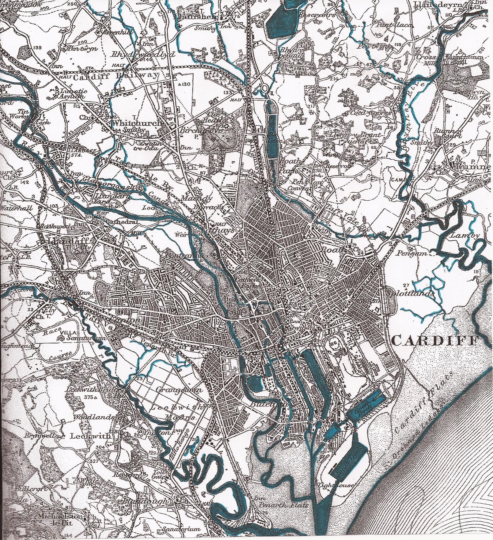
NOTE ALSO:
• The Glamorganshire Canal tracking the Taff’s east bank up the valley
• All 5 docks + 2 large timber ponds + connecting canals in Butetown
• The Dock Feeder between Blackweir and the West Dock
• Mill races on the Taff at Llandaf and the Rhymni at Llanrumney
• The start of the Melingriffith Feeder (top left)
• Tributary streams from the hills: left to right, Nant Nofydd, Briwnant (converging to form Nant Waedlyd), Nant Draenen, Nant Llanisien, Nant Fawr, Nant Dulas, Nant Pontprennau
Map: Cardiff Central Library/Dic Mortimer
Do you remember the outdoor swimming pool on Llandaff Fields? A beautiful place to swim, and filled from three springs, until the motorway was driven across the North of Cardiff. They promptly dried up, then it had to be filled with mains water.